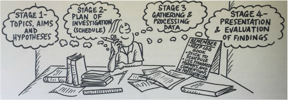
What do I research?

There are very few barriers to what you investigate for your Geographical research. All that is needed is a Geographical focus question.
The Senior Geography Project and IB Internal Assessment both require a reasonably local scale study, so you choose something that can be mapped and visited easily.
However, you could investigate how global changes or geographical theories manifest in your local area. You might also choose to contribute to a longitudinal study.
Some example Geographic Research Project ideas are presented here.
Planning your primary and secondary research
When considering which topic you will study, you should also consider how you will research it and what methods would be appropriate. It is often useful to select a topic that is based on a particular theory or model. This will give your research a good point of reference for evaluating a hypothesis.
Primary Research Methods
Great primary research starts with knowing specifically what you wish to know more about. This usually requires the researcher to have developed a sound understanding of a topic before designing their primary research methods. For any geographical research study the place of the investigation will also have a large role in determining the topic of the study.
Some of the key fieldwork methods are:
Selecting the right tool and designing a reliable and valid study will yield a great range of data that can be analysed and compared to secondary research.
Secondary Research Methods
There are many sources of information available and they vary in reliability and usefulness. They can be grouped into these categories:
A. Journal articles and databases (Most reliable)
B. Government data collections (very reliable)
C. Media and news agency (generally reliable, but can be poorly researched or bias)
D. NGO and stakeholder websites (highly variable. Should be considered biased.)
IB Geography internal assessment can utilise secondary data, however the report should be predominantly focused on a particular site. This gives limited opportunities for secondary research to be included.
Great primary research starts with knowing specifically what you wish to know more about. This usually requires the researcher to have developed a sound understanding of a topic before designing their primary research methods. For any geographical research study the place of the investigation will also have a large role in determining the topic of the study.
Some of the key fieldwork methods are:
- Interviews - best for gathering detailed, qualitative data from limited numbers of participants
- Questionnaires - best for gathering quantitative data from a large number of participants.
- Mapping / GIS
- Counting methods - good for showing change in an event over time.
- Observations/photographic comparisons
- Transects samples - good for sampling or demonstrating a change over space.
- Quadrat samples - good for random sampling.
- Biophysical sampling/field measurements - best for gathering quantitative data from environments.
Selecting the right tool and designing a reliable and valid study will yield a great range of data that can be analysed and compared to secondary research.
Secondary Research Methods
There are many sources of information available and they vary in reliability and usefulness. They can be grouped into these categories:
A. Journal articles and databases (Most reliable)
- library access databases provided excellent background reading.
- peer reviewed journal articles will provide high quality research information
B. Government data collections (very reliable)
- Census and A.B.S. Data will provide up to date statistics about populations
- Government department websites and fact sheets provide policy information and agendas
C. Media and news agency (generally reliable, but can be poorly researched or bias)
- News agencies will provide a useful introduction to a topic or range of perspectives
- news articles will usually have more accessible language and are easily found
D. NGO and stakeholder websites (highly variable. Should be considered biased.)
- NGOs usually conduct research on particular topics. This research can be very valuable
- small scale websites and blogs can be poorly researched or present only one perspective
IB Geography internal assessment can utilise secondary data, however the report should be predominantly focused on a particular site. This gives limited opportunities for secondary research to be included.
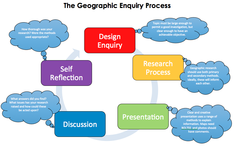
Research report structure and format
There are slight differences in the presentation requirements between the SGP and the IA. The word limits for particular sections act as a guide, more can be assigned to a particular section if balanced with less to another section.
Senior Geography Project
Fieldwork question(s) and Geographic context- 600 Methods - 400 words Research findings - 1300 words Conclusion - 200 Evaluation - Seperate verbal presentation Total - 2500 words |
IB Internal Assessment
Fieldwork question(s) and Geographic context- 300
Hypothesis - n/a Method of Investigation- 300 Research findings - 1 450 Conclusion - 200 Evaluation - 300 Total - 2450 words | ||||||
For both the SGP and IA there are conventions to ensure uniform presentation. These MUST be followed and contribute to the marking of the assessment task.
SGPs and IAs must meet the following five formal requirements of organisation and presentation.
Maps
Maps should be student-generated, either by being hand drawn or computer-derived, and they must be made relevant to the study. Maps that are downloaded or photocopied should be adapted to the student’s own information and this may be achieved effectively by overlays. Normal B.O.L.T.S.S. map conventions must be followed.
SGPs and IAs must meet the following five formal requirements of organisation and presentation.
- The work is within the word limit (2500 words).
- Overall presentation is neat and well structured into sections with headings and subheadings.
- Pages are numbered.
- References used for background information follow Harvard referencing
- All illustrative material is numbered, is fully integrated into the body of the report and is not relegated to an appendix.
Maps
Maps should be student-generated, either by being hand drawn or computer-derived, and they must be made relevant to the study. Maps that are downloaded or photocopied should be adapted to the student’s own information and this may be achieved effectively by overlays. Normal B.O.L.T.S.S. map conventions must be followed.


Tables and Graphs
Any tables should have a non-variable in the first column and be clearly labeled with headings. Graphs should be suitable and preferably constructed to suit the project.
Images
All photos and images should be numbered and have a caption explaining their significance. Images can also be annotated for indicate significant features.
Appendices
A very limited use of appendices is acceptable and, if appendices are used, these should contain only examples of materials that have been used or are representative of the material used, such as a data sheet or a translation of a questionnaire. It should not include all materials used, for example, every survey or questionnaire completed. Further, it should not include secondary information.
A very limited use of appendices is acceptable and, if appendices are used, these should contain only examples of materials that have been used or are representative of the material used, such as a data sheet or a translation of a questionnaire. It should not include all materials used, for example, every survey or questionnaire completed. Further, it should not include secondary information.
Fieldwork analysis methods
Once the researcher has gathered their data, it is advised that they perform some statistical analysis of the results to look for relationships or correlations.
The easiest method is to graphs the distribution of results and looks for an obvious relationship. A scatter graph is often used for this purpose.
The easiest method is to graphs the distribution of results and looks for an obvious relationship. A scatter graph is often used for this purpose.
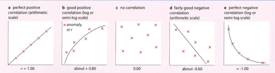
Chi Squared Test
The Chi Squared (pronounced "Ki Squared") statistical test is used to determine in there is relationship between to or more discrete variables.
The Chi Squared (pronounced "Ki Squared") statistical test is used to determine in there is relationship between to or more discrete variables.
|
|
|
|
spearman's rank correlation coefficient is used to statistically confirm a relationship between the rank of two variables.
Both Chi squared tests and spearman's rank correlation coefficient have quite specific uses and it would be best to consider their use in the initial design of the study. |
|
Evaluations and Ethical research
Evaluating your research
It is important that research can be replicated and that sources of potential inaccuracy or aspects of poor research design can be recognised. Ideally, there will be reasons why the researcher knew these existed but chose to continue anyway. For examples 50 samples in a questionnaire might not be a very large sample, however for the time and cost available to a high school students it is quite sufficient.
It is important that research can be replicated and that sources of potential inaccuracy or aspects of poor research design can be recognised. Ideally, there will be reasons why the researcher knew these existed but chose to continue anyway. For examples 50 samples in a questionnaire might not be a very large sample, however for the time and cost available to a high school students it is quite sufficient.
Risk
Researchers should never put themselves or anyone else in harms way. Avoiding exposure to physical and/or emotional risks or harm requires some fore thought for particular research topics. Students should also be careful in giving out any personal details on the internet or to strangers.
Responsibility
Research should not harm the environment in any way. This involves:
Whenever using other people's work, it should always be acknowledged or referenced. Acknowledging source materials requires use of the Harvard, in-text referencing method and a supporting bibliography. Students must also observe the usual academic conventions regarding plagiarism.
Some of the other key aspects of ethical research include:
Researchers should never put themselves or anyone else in harms way. Avoiding exposure to physical and/or emotional risks or harm requires some fore thought for particular research topics. Students should also be careful in giving out any personal details on the internet or to strangers.
Responsibility
Research should not harm the environment in any way. This involves:
- obtaining permission and avoiding trespass
- minimising damage to landscapes or environmental elements
Whenever using other people's work, it should always be acknowledged or referenced. Acknowledging source materials requires use of the Harvard, in-text referencing method and a supporting bibliography. Students must also observe the usual academic conventions regarding plagiarism.
Some of the other key aspects of ethical research include:
- respecting confidentiality and anonymity
- avoiding use of deception or coercion with informants
- storing data appropriately